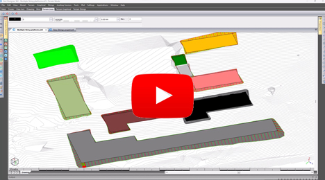
Advanced Terrain Modelling
Advanced survey calculations and draughting routines for bulk earthworks, terrace or dam wall design including material volumetrics and haulage optimization.
Discover Key Features
- Draft Expert – automated draughting from raw survey data
- Multiple terraces with cut/fill optimisation
- Platform & terrace design using relational 3D string method
- Rapid dam water surface area and volume calculation
- Calculate volumes between any 2 of 255 surfaces
- Powerful survey reduction routines
- Observations and figures database for all survey calculations
- Crossing services displayed on plan, long and cross-sections
- Extract long and cross-sections along any alignment
- Draw crossing services for terrain strings long section plots
- Bank lines can be drawn across multiple surfaces
- Survey calculations, error figures and control surveys
- Partnered Terrain Providers: GeoSmart Space (RSA)
We appreciate the time saving features
"We used Civil Designer for the bulk earthworks, roads, and for designing all the stormwater, sewer, potable and semi-purified water infrastructure services. We appreciate the software's time saving features and the excellent support service." -Heiko Fleidl, BSc.Eng (Civil), WCE Consulting Engineers, Windhoek, Namibia.There is no comparison in price or support
"After considering the opposition, there is no comparison when it comes to either price or support. Civil Designer keep adding new and useful features and the support service is first class." -Steven Mann, Pr Eng Pr CPM, Engineering Advice & Services (Pty) Ltd.

The module imports 4 million points in under a minute and can handle 95 million points with ease
Find out More
Download a detailed pdf brochure