Design Centre
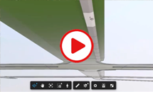
Design Centre is the platform module and combines a bespoke CAD, aerial image handling, and powerful digital terrain modelling, providing all the functionality required to produce your final drawings.

Discover Key Features
Fully interoperable. Supports BIM IFC 4Ă—3 R2 Import and Export. Share design model information within your common data environment.
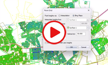
Survey Compatibility. Import survey information to your DTM via 3D drawing entities or using TIFF DEM, Lidar surveys, LandXML or ASCII files.
Northern and Southern hemisphere coordinate systems. Initiate your project with correct geo-referencing to prevent later problems.

Collaborative licensing. The Design Centre platform module enables you to collaborate and share module licenses across your team.

Large image handling. Multiple, large images such as orthophotos or aerial survey images can be quickly loaded into your project.

Powerful modelling and plotting. (4 different grades). Work with multiple (400+) dynamically updated drawing layouts and viewports.
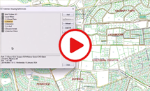
Logical layouts. Embedded drawings (Xrefs) can be loaded and unloaded, blocks and coordinate tables are kept in sync.

Sheetfile functionality. Our drawing templates (sheet files) allow you save you hours of post-production CAD editing.
Supported by civil engineering professionals
"I have used Civil Designer for 25 years. It is developed and supported by civil engineering professionals who really understand the challenges we face." -Carlos Dos Santos, Associate at AECOM.Time saving features
"We appreciated Civil Designer’s time saving features and their technical support service is second to none." -Sakkie Nieuwoudt, Civil Engineer at Endecon Ubuntu, Limpopo, South Africa.

The program imports 4 million points in under a minute and can handle 95 million points with ease
Find out More
Download a detailed pdf brochure