27 Jul Stormwater Rainfall Runoff
Urban development, and the construction of buildings and roads, modifies stormwater flow conditions by generating more surface runoff instead of soil infiltration. Extending impervious ground area not only increases the risk of overloading the receiving watercourse or sewer, but also lowers local groundwater levels and increases the pollution load in the runoff.
Runoff Control Measures
Developers, civil engineers and those involved in reviewing planning applications need to be able to assess the runoff impact of new developments and ensure that adequate control measures are implemented. As urban populations grow, existing stormwater networks will also require resizing and reinforcing in order to maintain their effectiveness. Culverts, underground stormwater pipe networks, catchment areas, storage tanks and open ponds are designed or defined in accordance with the predicted runoff both for average rainfall and rare weather events.
Runoff Simulation Methodologies
Established rainfall-runoff simulation models draw on a number of methodologies that consider historical flood data, geographical and soil permeability categories, water source intensity, rainfall duration, and kinematic-wave model approximations in order to simulate runoff events. Summaries of some of the more widely used methodologies are included in the appendix below.
The civil engineer must take all the relevant environmental features into account, and then apply the most suitable simulation methodology according to the project at hand in order to ensure that average and rare rainfall occurrences are adequately handled by the control measures.
Stormwater Network Design and Analysis using Civil Designer Software
Civil Designer is an integrated infrastructure design platform which places tried and trusted civil engineering principles at the hands of the engineer, while ensuring all relevant data is represented in the design model.
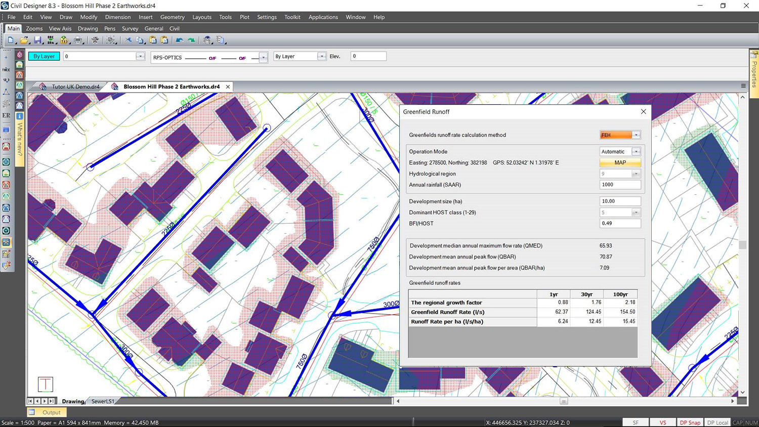
Greenfields runoff rate calculation
Civil Designer’s Storm module is a comprehensive tool for the design and analysis of gravity based pipe networks. Illudus, Rational, Wallingford, SWMM and Greenfields (IH124 and FEH methods1) runoff models can be applied in the model calculations.
The program will simulate a complex system of detention storage, overflows and dual runoff so that you can model the intricate networks that are typical of modern cities. Each model may have multiple sub-networks and outfalls. You may specify the outfall levels if you wish to connect to existing systems. Alternatively, the program will determine the best possible outfall level in accordance with the design parameters.
Civil Designer’s Storm module allows the efficient design and modification of stormwater networks and gives the engineer control to apply the required and most suitable design principles, according to the project at hand.
For Reference: Widely Adopted Rainfall Runoff Models
ILLUDAS Runoff Models
The ILLUDAS (Illinois Urban Drainage Simulator) Time-Area method is used for the estimation of runoff from a uniformly distributed design storm over a catchment area (which can be divided into homogenous sub-catchment areas) which drains into an inlet. The Illudas methodology assumes that overland flow is the sole source of storm runoff. Losses due to infiltration and surface irregularities are subtracted from the rainfall to determine the excess precipitation.
Rational Runoff Models
The Rational Method is an intensity-based rainfall prediction method that can be used to estimate peak flows, according to the watershed characteristics and the rainfall event. The peak flow calculation considers rainfall intensity over a given length of time, for a specified drainage area, and uses a runoff coefficient to determine the peak discharge into a drainage basin.
EPA SWMM
In the early 1970s, the United States Environmental Protection Agency developed their own Storm Water Management Model (SWMM) in order to support stormwater management objectives. SWMM is a dynamic rainfall-runoff simulation model used for single event or long-term (continuous) simulation of runoff quantity and quality from primarily urban areas. The runoff component of SWMM operates on a collection of subcatchment areas that receive precipitation and generate runoff and pollutant loads. The routing portion of SWMM transports this runoff through a system of pipes, channels, storage/treatment devices, pumps, and regulators. SWMM tracks the quantity and quality of runoff generated within each subcatchment, and the flow rate, flow depth, and quality of water in each pipe and channel during a simulation period comprised of multiple time steps.
The Wallingford Methodology (UK)
The Wallingford Procedure was developed in the 1970s and 1980s to improve the estimation of rainfall runoff in the UK. It is based on the Rational Method, and is sometimes referred to as the Modified Rational Method. The Wallingford Procedure relies on historic data including a national scale study of information from hundreds of rain gauges which was used to create a map of rainfall intensities and characteristics for the whole of the UK. Using location based values within the UK, the design rainfall intensity can be estimated for any storm duration and any return period, for any site.
Greenfield Runoff (UK)
The Greenfield runoff rate estimation is an online tool, developed to assist developers, drainage engineers and those involved in assessing planning applications with the calculation of greenfield runoff rates for new developments. The methodology is a map-based tool (UK only) which calculates flow rates using historical catchment runoff and data from numerous flood studies, and incorporates a runoff coefficient derived from location based soil category definitions. Greenfield runoff is usually calculated as the peak rate of runoff for a specific return period due to rainfall falling on a given area of vegetated land. Factors not taken into account include the vegetated land characteristics (whether it is treed or farmed for example), the gradient of the site and rainfall intensity.
1The Greenfields FEH method is a statistical method based on the Flood Estimation Handbook which replaced the UK Flood Studies Report in 1999. The Greenfields IH124 was specifically produced to address the runoff from small catchments. Civil Designer software can implement Greenfields runoff calculations according to UK National SuDS standards and the user has the option to use either the IH124 or the FEH methods for the runoff calculations.